
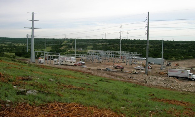
SAM conducted all surveying, aerial mapping and SUE services for the engineering design survey, easement documentation, construction staking, as-built of final construction, and preparation of ALTA Surveys for a 225 mile electric transmission line and three associated sub-stations. The project traversed 11 counties in Texas and consisted of approximately 250 individual parcels, and was completed in less than 18 months. Prior to this, a project of this magnitude and speed had never been attempted or accomplished anywhere in the country. SAM is proud to have been a successful part of this highly acclaimed project.
Surveying
In order to meet the less than 18 month project schedule, SAM mobilized up to 14 field survey crews and provided an on-site 3 person field crew supervisor support group. The crews worked 12 day on and 2 day off work schedule for the entire project through completion.
SAM dedicated office staff consisted of five Professional Land Surveyors and up to 15 survey technicians and support staff to process and prepare all electronic drawing files and required documentation for final deliverables. SAM deliverables consisted of the preparation of more than 220 ALTA surveys, and 220 sets of easement documents for recordation.
SUE
The first phase of the project consisted of sweeping a corridor 180’ wide by 225 miles long. As a result of the daily production of data, the client was able to make timely business decisions to change the final route of the electric transmission line. SAM was able to quickly sweep the new alignments without affecting the project schedule. As final structure and anchor locations were identified, SAM performed final sweeping ahead of the six to eight drilling rigs that worked concurrently over the entire 225 mile corridor.
To uphold the six month project schedule SAM supplied as many as five SUE crews that worked a 12 day on and 2 day off work schedule until completion. An office staff of technicians and engineers were dedicated to the support of the field operation and daily updating of the mapping data, and were available to the client for questions and meetings at all times to immediately provide resolution on project issues.
Aerial Mapping
SAM obtained full coverage vertical color aerial photography of a 20 mile wide corridor (10 miles left/right) centered on the route at an approximate scale of 1”=667’ (4,000’ Above Mean Terrain – AMT). We also acquired a 1 mile wide corridor of airborne LiDAR data at 1.7 points per square meter to produce a DEM sufficient for producing 2” contours. Over 122 flight lines and 12,000 plus exposures were bundle adjusted using a least squares solution for all ground control, ABGPS/IMU and photogrammetric observations.
SAM technicians mapped all visible planimetric features at a scale of 1”=100’. In areas where the route moved outside the LiDAR coverage, we compiled breaklines and masspoints to produce a DTM for the surface. Orthophoto images were rectified to the compiled DTM/DEM, mosaicked together and tonally balanced at the seamlines to create a homogeneous data set that was cut into 1000’ wide sheets along the corridor.


